I have never seen the original B/W photograph. Thus, I cannot make a comparison with the main postcard.
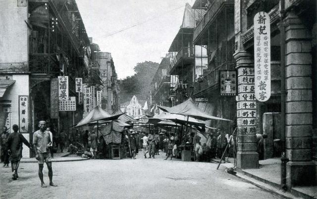
The photograph has been later turned into a postcard, a B/W version as seen above and a coloured/tinted one. The coloured postcard is annotated at the bottom "Chinese St. Stalls, Hong Kong".
Another coloured postcard showing the same scene is shown below. "Chinese Street, Stalls, Hong Kong" is also annotated.
In both coloured postcards, the actual location is not given. What appears to be a "church" in the main postcard is not apparent in the coloured one below. Looks like an awning or canopy in the background instead.
I do note in the public archive "Hong Kong Memory" as seen here that Hillier Street is given as the location of the main postcard.
Street numbers and lots are on Wanchai Road opposite the junction with Cross Street. So actually there was a chapel, but that does not necessarily mean that the photo shows Cross Street instead of Hillier Street.
So far, the possibility of Hillier Street (as in "Hong Kong Memory") can be eliminated.
In the colour photo, we can see the component of sunlight pointing into the photo, to the photographer’s left.
For the southern section of Hillier Street, it means the sun's azimuthal angle has to be between 300 deg – 30 deg (0 deg being North), which is impossible in HK with that sun elevation shown.
I think an actual photo of the “chapel” should provide some photographic evidence. Does anyone have such photo of the chapel on Wanchai Road at street level?
Sadly no close-up was found in the attempts/discussions happened elsewhere.
There are only some panorama from which the chapel and the building in the adjacent north could be extracted below for comparison. Hope someone would upload a close-up soon for an independent guess.
The collage also includes Hillier Street at the bottom, though with the study of the sun and shadow it is a weak candidate. But when reasonable questions arise, it’s always good to check.
Impressive work. I had a look around as well for similar sources of information but unfortunately only overhead views of Wanchai and the neighbouring area of Cross Street could be found.
Agree, with reference to the chapel, Cross Street appears to be a better candidate for the location showing possibly Hospital Hill in the background. That said, I find it difficult the match-up the buildings on the left side of Cross Street in the coloured postcards with the overhead views unless rebuilding works had taken place. A view of Wanchai Road and Cross Street here
For the comparison with the Wanchai photo in the link provided, there are definitely more to explore. Not entirely related to the topic photo, but can be briefly described here. Together with other Wan Chai photos, let's name them as:
[1] and [2] are the same photo but are labelled in different decades. [3] is later than [1] but this is not consistent with chrono order shown by the year labels. I guess this, again, shows the fun (and importance) of looking into the details in the captions used by the image sources.
/**************************************/
Putting aside the time for now, the topic photo may match better with, e.g. a photo of 1930's or later, which is from the same photo as the top right part of the collage. "1930's or later" is alright, as new buildings are already there on the new reclaimed land on the north of present the Hennessy Road.
With the assumption of being Cross Street, a time window could be drawn with other handles for cross-checking, e.g. with this https://gwulo.com/media/14627
Comments
Is that a church in the
Is that a church in the distance at the end of the road?
Regards, David
House with Church-like Spire
HK Island Roads and Streets by Cheng Po Hung pg 17
The house with the church-like spire in the background was rebuilt as the Central Theatre in the 1930s. (Not sure if it was a religious institution.)
HKGRO
Central Theatre was completed in 1930 and located at Queen's Road Central and Circular Pathway. Further information provided here
I added a place for this
I added a place for this corner.
Wan Chai
Cross Street in Wan Chai, looking east towards Wan Chai Road.
Discussions at: https://www.facebook.com/groups/hkwanchai/posts/10159282817717387/
Re: Main Postcard
I have never seen the original B/W photograph. Thus, I cannot make a comparison with the main postcard.
The photograph has been later turned into a postcard, a B/W version as seen above and a coloured/tinted one. The coloured postcard is annotated at the bottom "Chinese St. Stalls, Hong Kong".
Another coloured postcard showing the same scene is shown below. "Chinese Street, Stalls, Hong Kong" is also annotated.
In both coloured postcards, the actual location is not given. What appears to be a "church" in the main postcard is not apparent in the coloured one below. Looks like an awning or canopy in the background instead.
I do note in the public archive "Hong Kong Memory" as seen here that Hillier Street is given as the location of the main postcard.
Food for thought.
Re: Cross Street
The 1937 HK Street Index refers on page 243:
Street numbers and lots are on Wanchai Road opposite the junction with Cross Street. So actually there was a chapel, but that does not necessarily mean that the photo shows Cross Street instead of Hillier Street.
More about this school and chapel here.
Re: Main Postcard
True, Cross Street only remains as a candidate.
So far, the possibility of Hillier Street (as in "Hong Kong Memory") can be eliminated.
In the colour photo, we can see the component of sunlight pointing into the photo, to the photographer’s left.
For the southern section of Hillier Street, it means the sun's azimuthal angle has to be between 300 deg – 30 deg (0 deg being North), which is impossible in HK with that sun elevation shown.
Re: Main Postcard
I think an actual photo of the “chapel” should provide some photographic evidence. Does anyone have such photo of the chapel on Wanchai Road at street level?
Re: Main Postcard
Sadly no close-up was found in the attempts/discussions happened elsewhere.
There are only some panorama from which the chapel and the building in the adjacent north could be extracted below for comparison. Hope someone would upload a close-up soon for an independent guess.
The collage also includes Hillier Street at the bottom, though with the study of the sun and shadow it is a weak candidate. But when reasonable questions arise, it’s always good to check.
Re: Main Postcard
Impressive work. I had a look around as well for similar sources of information but unfortunately only overhead views of Wanchai and the neighbouring area of Cross Street could be found.
Agree, with reference to the chapel, Cross Street appears to be a better candidate for the location showing possibly Hospital Hill in the background. That said, I find it difficult the match-up the buildings on the left side of Cross Street in the coloured postcards with the overhead views unless rebuilding works had taken place. A view of Wanchai Road and Cross Street here
Re: Main Postcard
For the comparison with the Wanchai photo in the link provided, there are definitely more to explore. Not entirely related to the topic photo, but can be briefly described here. Together with other Wan Chai photos, let's name them as:
[1] "1910 Wanchai view" https://gwulo.com/media/23432
[2] "1900s Native quarter from the Peak" https://gwulo.com/media/46154
[3] "1900s View of the City and Harbour between Hongkong and Kowloon" https://gwulo.com/media/46156
[1] and [2] are the same photo but are labelled in different decades. [3] is later than [1] but this is not consistent with chrono order shown by the year labels. I guess this, again, shows the fun (and importance) of looking into the details in the captions used by the image sources.
/**************************************/
Putting aside the time for now, the topic photo may match better with, e.g. a photo of 1930's or later, which is from the same photo as the top right part of the collage. "1930's or later" is alright, as new buildings are already there on the new reclaimed land on the north of present the Hennessy Road.
With the assumption of being Cross Street, a time window could be drawn with other handles for cross-checking, e.g. with this https://gwulo.com/media/14627
Re Main Postcard
Good work. The buildings on the left side of Cross Street in the main postcard match up well with the photo sources provided.
Chapel
Think the chapel can be seen on the photo below left of Hospital Hill:
It seems clear now that the location has been confirmed. I will update the main post.